
Introduction to Tasmania’s Western Edge
The geography of western Tasmania represents one of the most complex and fascinating logistical challenges in the Southern Hemisphere. In this Australian insular outpost, where the roaring winds of the roaring forties relentlessly batter quartzite cliffs, connectivity is not merely a matter of tourist convenience, but a question of economic survival and territorial cohesion. For decades, this isolated territory has relied on a delicate balance between historical infrastructure and contemporary transport solutions that adapt to an unforgiving natural environment.
To understand the real pulse of this region, one must delve into its intermodal framework, where high-mountain roads, repurposed historic timber railways, and coastal navigation maintain a constant dialogue with meteorology. Far from the conventional urban circuits of Hobart or Launceston, the western strip demands that travelers and planners deeply comprehend distances, transit times, and the physical limitations imposed by dense temperate rainforests and deep river estuaries.
The Terrestrial Backbone: Roads Through Ancient Forests
Road access to western Tasmania relies fundamentally on the arterial route known as the Lyell Highway. Carved largely during the past century through rugged mountainous terrain, this route acts as the umbilical cord connecting the island’s center with historical mining and industrial settlements such as Queenstown and Strahan. Civil engineering here has had to negotiate meter by meter with steep gradients, sharp curves, and an unstable geological surface.
The maintenance of these routes represents a constant budgetary and technical challenge for state authorities. Annual precipitation, which in some areas exceeds three thousand millimeters, causes recurrent landslides and accelerated asphalt erosion. Local transporters and long-distance bus operators must work under strict safety protocols, anticipating temporary road closures due to snow in high-mountain passes or the falling of giant trees during winter storms.
The Railway Legacy and Its Tourist Transformation
Alongside roads, the region’s railway heritage tells a story of industrial tenacity. The iconic West Coast Wilderness Railway rack-and-pinion line, which once hauled copper ore from the Mount Lyell mines to the port of Strahan, survives today as a masterpiece of nineteenth-century engineering. Although its original commercial function ceased decades ago, its preservation and current operation demonstrate how historical infrastructure can be repurposed to keep the local economy alive through specialized tourism.
The Huon Pine timber bridges and the complex rack mechanisms that allow steam locomotives to overcome extreme gradients undergo meticulous maintenance. This rail corridor not only carries passengers seeking heritage experiences but also serves as a tangible reminder that connectivity in Tasmania has always required ingenious mechanical solutions to master a vertical, forested topography.
Maritime Facade: Sheltered Harbors and Coastal Cabotage
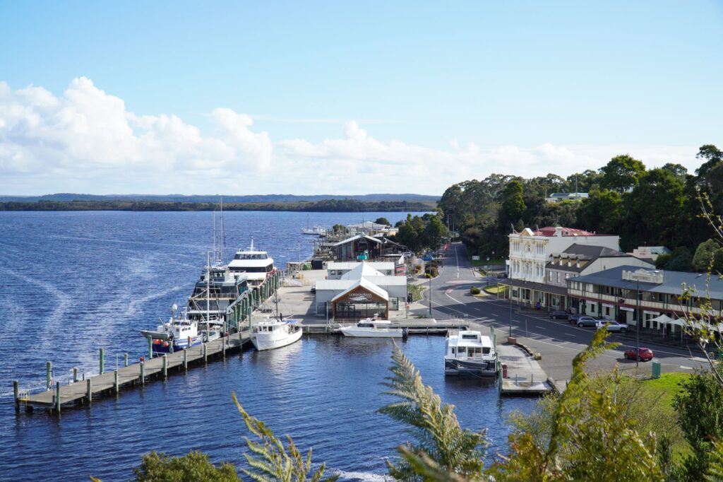
If land imposes formal barriers, the sea offers the historical route of penetration into the western coast. The port of Strahan, situated at the mouth of the Gordon River and protected by the dangerous and narrow ocean bar known as Hell’s Gates, has historically been the nerve center of maritime trade and fishing in the region. Navigation in these waters requires pilots with comprehensive knowledge of tidal currents and shifting sandbars.
Today, commercial cabotage has declined in favor of road transport, but the maritime facade remains vital for the aquaculture sector, sustainable forestry, and expedition tourism. Tour vessels navigating up the Gordon River into the heart of the Southwest National Park operate with millimeter precision, respecting strict environmental regulations to protect the delicately balanced riverside ecosystems.
Estuary Management and Minor Port Infrastructure
Further north, small enclaves and inlets rely on docks and boat ramps that withstand the harsh conditions of the Southern Ocean. Port infrastructure on this coast does not feature deep-water basins, but rather natural shelters conditioned by breakwaters and periodic dredging. Provisioning logistics for the most isolated coastal communities depend on the punctual arrival of barges capable of weathering unexpected gales and swells.

Artisanal fishermen and local tour operators share these port spaces, where maritime solidarity is an essential requirement for daily operations. State port authorities continually invest in meteorological monitoring systems and advanced navigational aids to mitigate the risks inherent in coastal approaches during low-visibility conditions.
Air Connectivity and Emergency Services
Due to the scarcity of large flat expanses and adverse weather conditions, scheduled commercial aviation does not operate major airports on the west coast. However, grass and gravel airstrips located in towns such as Strahan and Zeehan play a critical role in emergency connectivity, medical evacuation, and the transport of specialized personnel for conservation and national park management.
Light aviation and rescue helicopters are often the only rapid means to connect these territories with complex hospitals in Hobart or Launceston when main roads are blocked by extreme weather events. This reliance on bush flying underscores the structural vulnerability of a region where geographical isolation can materialize within hours.
The true measure of infrastructure on western Tasmania’s coast is not calculated in tons of poured asphalt, but in the ability to maintain an invisible thread of life and supply when the weather decides to cut off all other paths.
Pilots operating along this route must hold specific certifications to fly between enclosed valleys and deal with sudden crosswinds generated by the interaction between the ocean and coastal mountain ranges. Their silent labor ensures that technical and medical assistance is never completely interrupted, consolidating an invisible yet essential safety network for permanent residents.
Socioeconomic Challenges and Local Resilience
The reliance on such a vulnerable transport system generates continuous debate regarding the region’s economic sustainability. With a dispersed population and an economy traditionally based on natural resource extraction, the transition toward a tourism and conservation model demands modernizing investments in telecommunications and sustainable mobility that are not always profitable under strict market criteria.
Local communities have demonstrated a notable capacity for adaptation, organizing transport cooperatives and neighborhood support networks to cope with supply chain disruptions. This resilient social fabric often compensates for the structural deficiencies of a communications network that constantly struggles against the physical wear and tear inflicted by the environment.
Practical guide
Planning a trip or a logistical operation on western Tasmania’s coast requires rigor and foresight due to the unique characteristics of its intermodal transport network.
- Land transport: Renting four-wheel-drive vehicles is essential if you plan to venture off primary routes (Lyell Highway and Murchison Highway). Always check road conditions on the official TasNetworks portal and Tasmania Police website before starting any journey.
- Maritime connectivity: Boat excursions on the Gordon River and Strahan harbor operate on schedules subject to weather conditions. Advance booking is recommended, along with a contingency margin of at least one day in your itinerary for possible cancellations due to wind or swell.
- Fuel and supplies: Service stations in the western region are spaced farther apart than on the east coast. Refuel whenever your tank drops below half and keep emergency water and warm clothing in your vehicle.
- Communications: Mobile phone coverage outside urban centers like Queenstown, Strahan, and Zeehan is extremely limited. Download offline maps and consider using satellite communication devices if undertaking remote trips or advanced bushwalking.
Final Reflection on the Western Horizon
Contemplating the dark waters of Strahan harbor at sunset, tinted by tannin-rich sediments from interior rivers, one understands that the infrastructure of western Tasmania’s coast is much more than a collection of roads, railways, and docks. It is a daily pact between human will and overwhelming nature that resists being fully tamed. In this Australian outpost, every successfully completed journey stands as a testament to mutual respect and the endurance of a connectivity that, despite its apparent fragility, firmly sustains the vital heartbeat of entire communities.