Introduction to the Seto Inland Sea and its insular challenge
The Seto Inland Sea, the body of water separating Japan’s main islands of Honshu, Shikoku, and Kyushu, has historically represented a geographical barrier as fascinating as it is complex for overland transport. For centuries, the sole means of communication between these insular territories relied upon maritime navigation, subject to unpredictable tides and the shifting weather patterns of the Pacific. However, the second half of the twentieth century marked a radical turning point in Japanese civil engineering with the conceptualization and subsequent execution of the Honshu-Shikoku Bridge Project, a colossal masterpiece designed to unite the islands through an uninterrupted series of highways and railway links.
Among the enabled corridors, the central route running through the Honshi-Bisan line and the combined infrastructure of the grand Seto Ohashi Bridge stands out not only for its technical daring, but for having irreversibly transformed the socioeconomic connectivity of Shikoku. This report examines with documentary rigor how Japanese railway engineering managed to defy marine currents, geological fault lines, and spatial constraints to cast a bridge of steel and concrete across the sea, enabling high-speed trains and commuter convoys to cross the waters of Seto daily with unmatched chronometric precision worldwide.
The genesis of the Honshu-Shikoku Project and territorial planning
The idea of connecting Honshu to Shikoku via a fixed link did not emerge from improvisation, but from a long gestation of feasibility studies that began taking formal shape in the 1950s. The Ministry of Construction and the now-defunct Japanese National Railways (JNR) evaluated three potential routes: the eastern (Kobe-Naruto), the central (Kojima-Sakaide), and the western (Onomichi-Imabari). Of these, the central route—formally known as Seto Ohashi—was prioritized to house a dual-use system: a highway on the upper deck and railway tracks suitable for passenger and freight trains on the lower deck.
This approach required unprecedented coordination among geological engineers, naval architects, and urban planners. The fundamental premise was to minimize disruption to commercial maritime traffic heavily utilizing the Inland Sea, while ensuring structural stability against recurring earthquakes and seasonal typhoons. Topographical constraints on both shores forced the design of exceptionally long elevated viaducts that progressively extend into the marine environment, subtly yet permanently altering the silhouette of the minor archipelagos dotting the bay.
Viaduct architecture and the deployment of the railway track
The railway section of the Seto Ohashi is not a uniform structure, but a system composed of six main bridges and five approach viaducts totaling over thirteen kilometers in length, of which nearly nine stretch directly over the sea. Among the most notable structures are the Shimotsui-Seto suspension bridge, the Hitsuishijima cable-stayed bridge, and the Iwakurojima truss bridge. Each structural typology responded to specific mechanical demands imposed by sea depth, seabed composition, and the need to support heavy dynamic loads.

On the lower deck of this metallic superstructure, two standard-gauge tracks (1,435 mm) were installed, originally designed to accommodate a future extension of the Shinkansen (bullet train) system, though they currently operate primarily with limited express train services and local commuter convoys operated by JR Shikoku. Laying the tracks required implementing specialized expansion joints capable of absorbing the thermal expansion of steel under extreme summer temperatures, as well as advanced anti-vibration dampening systems to protect the integrity of the main girders against the constant passage of trains at high commercial speeds.
Marine geotechnics and foundation work under extreme conditions
One of the greatest challenges faced by construction teams during the 1980s was founding the massive reinforced concrete pylons directly onto the seabed of the strait. Unlike land-based projects, engineers had to contend with tidal currents reaching speeds of up to ten knots and highly irregular submerged rock strata. To resolve this, gigantic prefabricated steel caissons were towed to the exact location, lowered in a controlled manner, and subsequently filled with high-strength underwater concrete.
Furthermore, the archipelago’s location within one of the world’s most seismically active zones mandated the incorporation of pioneering aseismic design criteria. The bridge foundations were engineered to withstand earthquakes exceeding magnitude 8.0 on the Richter scale, integrating elastomeric bearings and kinetic energy dissipation devices that allow the towers to oscillate in a controlled manner without compromising the alignment of the railway tracks located on the lower deck, thereby averting any risk of unexpected derailment.
Railway operations and integration with Honshu and Shikoku networks
The commissioning of the railway link in the late 1980s immediately reconfigured travel times between the Chugoku region in Honshu and the island of Shikoku. Previously, passengers were obliged to transfer to ferries at ports such as Uno or Takamatsu, a process requiring over an hour of additional maritime transit. With the bridge’s opening, limited express trains such as the Marine Liner began covering the distance between Okayama and Takamatsu in slightly under an hour, a milestone that invigorated regional commerce and tourism.

The logistical operation of this artery requires millimetric synchronization between JR West and JR Shikoku companies. Any weather disruption—such as sustained winds exceeding operational safety limits—forces the temporary suspension of railway traffic on the lower deck, triggering emergency protocols that reroute or hold convoys at the Kojima and Sakaide junction stations. This interdependence demonstrates how a high-mountain or, in this case, high-sea linear infrastructure becomes the critical circulatory system of an entire insular economy.
Socioeconomic impact and demographic pulse in Shikoku
Beyond the technical feat, the arrival of the train across the Seto Inland Sea sparked profound transformations in Shikoku’s demographics and economy. Cities such as Sakaide and Marugame experienced accelerated urban development around their terminal stations, attracting industrial investments and facilitating the commuting mobility of workers residing on the island but employed in the industrial urban centers of Honshu’s coast, such as Okayama and Kurashiki.
However, this bidirectional flow has also accentuated certain territorial imbalances, accelerating demographic exodus from rural and mountainous areas in interior Shikoku toward better-connected transportation axes. Regional planners continue to evaluate the balance between economic modernization driven by the railway and the preservation of traditional landscapes and fishing communities that have inhabited the Inland Sea shores for generations, maintaining a delicate equilibrium between technological development and cultural identity.

The precision of Japanese engineering is measured not solely in tons of steel assembled over the marine abyss, but in the absolute confidence with which thousands of passengers entrust their daily commute to an invisible line suspended between two worlds.
Practical guide
-
Key connection stations: The main terminals to access the Seto Ohashi railway corridor are Okayama Station in Honshu and Takamatsu Station in Shikoku. Both are fully integrated into the national Shinkansen high-speed network and JR regional systems.
Rail service types: The Marine Liner limited express trains operate with high daily frequency, connecting both islands in approximately 55 minutes. Certain seats require advance reservation, especially in double-decker cars featuring panoramic views.
Weather operational restrictions: During the typhoon season (summer and early autumn), railway services across the bridge may be temporarily suspended due to extreme wind gusts. Consulting real-time information panels provided by JR West is strongly recommended.
Route planning and fares: The journey is covered by most regional Japan Rail Pass tourist tickets, although specific conditions applicable to limited express trains operated in partnership with JR Shikoku should be verified in advance.
Visual epilogue over the waters of Seto
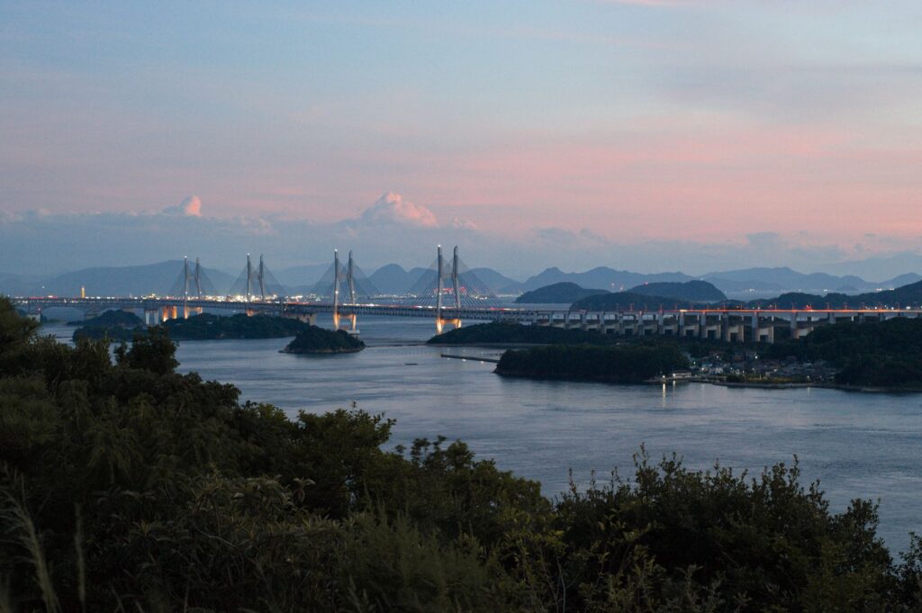
As the sun begins to descend over the labyrinth of islands and islets dotting the Seto Inland Sea, the monumental silhouette of the Seto Ohashi Bridge acquires an almost sculptural presence. The geometric lines of steel silhouette against a sky tinged with amber and violet hues, while the calm waters of the bay reflect the silent passage of traditional fishing boats still plying the channels beneath the imposing concrete structures. In that moment of crepuscular stillness, modern high engineering and the ancient serenity of the Japanese insular landscape converge into a postcard of profound emotional resonance, reminding the traveler that every great infrastructure is, in essence, a bridge cast toward the understanding of the territory.