

The Ocean Barrier Dividing Two Insular Worlds
Bass Strait is not merely a stretch of saltwater separating the island state of Tasmania from southeastern mainland Australia; it is one of the most unforgiving maritime corridors on the planet. With a relatively shallow average depth of barely sixty meters, this channel acts as a natural funnel where the violent westerly winds known as the roaring forties converge, generating weather conditions that put the resilience of any modern transport infrastructure to the test. For the nearly six hundred thousand residents of Tasmania, every ton of freight, every commercial vehicle, and every traveler depends on a logistics chain as vulnerable as it is essential.
Unlike other regions of the world where fixed links via bridges or undersea tunnels have revolutionized connectivity, Tasmania’s geographical isolation remains intact due to the sheer distance and the brutal nature of the marine environment. Navigation across this strait demands pinpoint precision from shipping lines, captains, and port authorities, turning the transit of passengers and roll-on/roll-off cargo into a complex choreography of naval architecture, advanced meteorology, and strict schedule management.
The High-Seas Fleet: Steel Giants Battling the Swell
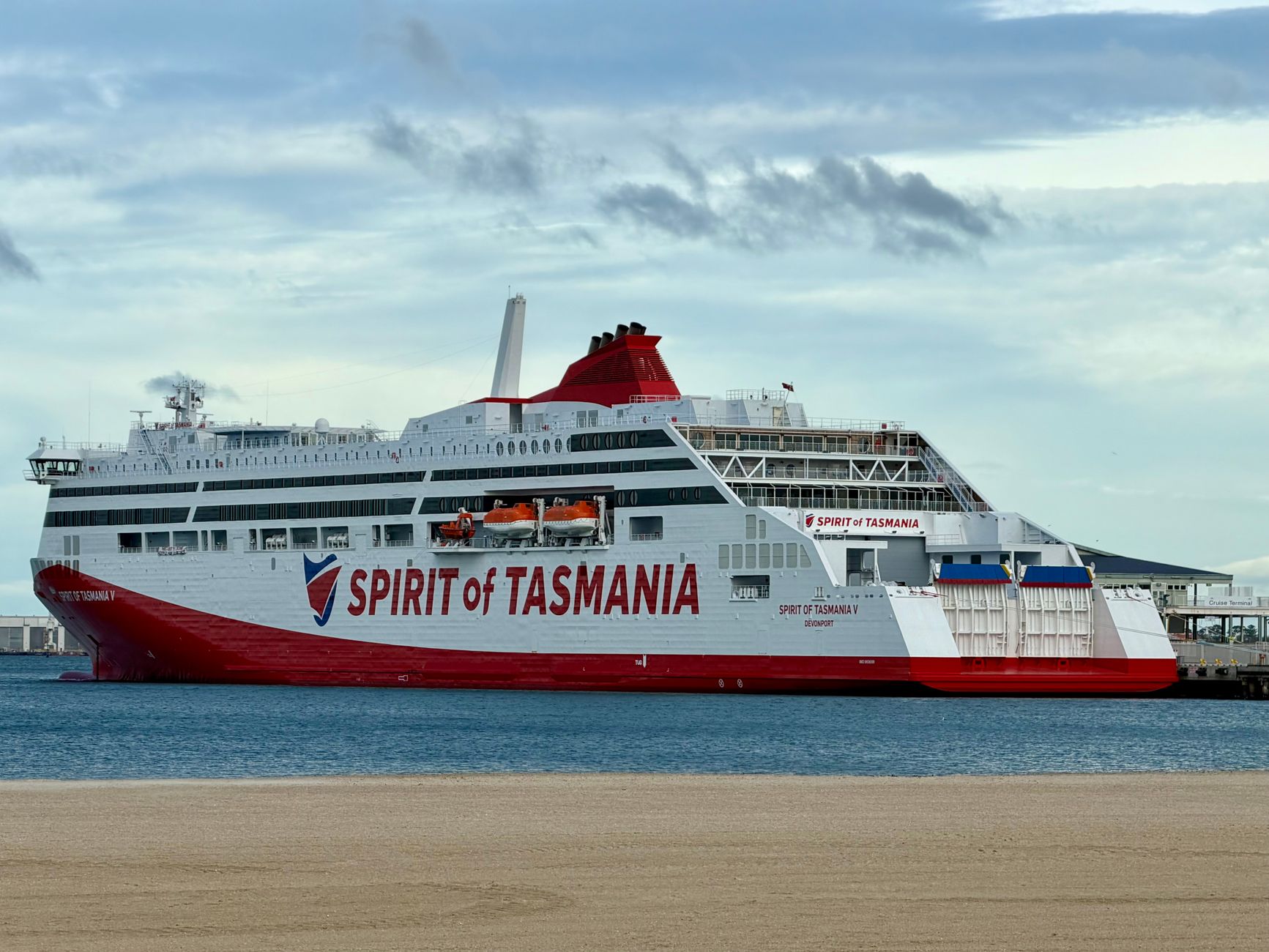
The core of surface connectivity between the Victorian port of Melbourne and the Tasmanian port of Devonport relies upon a specialized fleet of ro-pax ferries and roll-on/roll-off cargo vessels. These ships are not mere passenger carriers; they function as true floating extensions of national highways, designed specifically to absorb the impacts of massive waves without compromising structural integrity or cargo safety. The primary vessels operate overnight crossings year-round, covering a distance of approximately two hundred and forty nautical miles in an average time of nine to eleven hours.

The internal architecture of these steel colossi is optimized for multimodality. On the lower decks, heavy trucks laden with agricultural produce, timber, and manufactured goods line up, while passenger vehicles and comfortable seating areas occupy the upper decks. The stability of these vessels on the high seas depends on complex fin-stabilization systems and rigorous volumetric weight distribution, which are critical elements when the ship faces cross-swells and hurricane-force gusts sweeping across the center of the strait.
Bass Strait imposes an unyielding law where the margin of operational error is practically nonexistent and the ocean’s force dictates the economic rhythm of an entire island.
Extreme Weather and the Art of Strait Navigation
Weather forecasting in Bass Strait constitutes a scientific discipline in its own right. Ferry captains work closely with marine meteorologists to plot routes that minimize the impact of cold fronts originating from the Antarctic Ocean. When low-pressure systems collide with the mild air masses of the Australian mainland, waves can easily exceed eight meters in height, transforming the crossing into a top-tier technical challenge.
This constant climatic uncertainty forces shipping lines to maintain strict flexible operating protocols. Departure and arrival times are preemptively adjusted to avoid the peak of storms, which in turn triggers a domino effect on land supply chains in both Melbourne and Devonport. The ability to anticipate severe weather alerts is the difference between a safe voyage and a high-seas emergency, proving that satellite technology and state-of-the-art radars still rely heavily on expert human judgment.
Port Infrastructure: The Critical Nodes of Melbourne and Devonport
A maritime transport system is only as efficient as its land terminals. At the northern end of the corridor, the Port of Melbourne manages outbound logistics with industrial precision, coordinating the simultaneous arrival of freight trains and truck fleets before vessel loading. Rapid-access ramps and automated docking systems allow port turnaround times to be kept to an absolute minimum, maximizing the operational profitability of each crossing.
On Tasmania’s northern coast, the Port of Devonport serves as the primary gateway for road tourism and regional trade. Recent investments in berth expansions and the modernization of container-handling equipment have allowed it to accommodate longer and deeper-draft vessels. However, the steady growth in traffic volume requires ongoing upgrades to access roads and customs inspection zones—a crucial aspect for protecting Tasmania’s unique biodiversity from external pests.

The Economy of the Strait: Tasmania’s Umbilical Cord
For Tasmania’s economy, Bass Strait represents a literal umbilical cord. More than ninety percent of consumer goods and raw materials entering and leaving the island travel via this maritime route. Any prolonged disruption in ferry services—whether caused by labor strikes, unexpected mechanical failures, or severe storms—immediately triggers supply shortages in local supermarkets and delays in the export of perishable goods.
To mitigate this structural vulnerability, federal and state governments have implemented specific subsidies for freight transport costs, known as the Tasmanian Freight Equalisation Scheme. This measure seeks to offset logistical costs against mainland road transport, ensuring that island businesses can compete on equal terms in national and international markets despite being separated by an unbridgeable ocean barrier.

Passengers and Road Tourism: The Crossing Experience
Beyond its undeniable industrial and commercial value, Bass Strait is a passenger route of major tourism significance. Thousands of travelers choose each year to embark with their own vehicles to explore Tasmania’s wild landscapes and national parks without the constraints of car rentals. Shipping lines have responded to this demand by transforming ferries into high-quality travel experiences, equipped with private cabins, cinemas, dining rooms, and panoramic lounges.
n
Traveling by sea to Tasmania allows one to truly grasp the insular dimension of the territory, turning the transit journey into a fundamental stage of the travel adventure.
The vehicle boarding process requires meticulous organization where cars are classified by height, weight, and destination within the hold. Passengers must follow strict safety protocols during access and vehicle exit, ensuring that decks are completely cleared and sealed before the vessel casts off and confronts the vastness of the ocean.
Technological Challenges and Sustainability Along the Route
The future of maritime transport across Bass Strait is undergoing a deep transformation aimed at decarbonization and energy efficiency. Regulatory pressures and international environmental commitments require shipping companies to drastically reduce greenhouse gas emissions along a route that is particularly demanding in terms of fuel consumption due to heavy sea resistance.
Fleet renewal projects incorporate hybrid engines, propulsion systems based on liquefied natural gas, and optimized hull hydrodynamic designs. Additionally, shore-power connection technologies are being explored to shut down auxiliary engines during stays in Melbourne and Devonport, thereby reducing noise and air pollution in the urban environments adjacent to the port terminals.
Practical guide
- Best time to travel: From November to March, the austral summer months offer more stable weather conditions, although strong winds can occur at any time of the year.
- Advance booking: Space for vehicles and private cabins on the ferries must be booked several months in advance, especially during school holidays and the summer peak.
- Biosecurity restrictions: Tasmania enforces very strict biosecurity laws; bringing in certain fresh fruits, vegetables, plants, and soil material without declaration is strictly prohibited.
- Motion sickness preparation: Even experienced travelers can be affected by the strait’s swells; it is advisable to carry preventive medication and consult onboard staff.
- Vehicle documentation: Ensure that your car insurance policy covers maritime transport between the mainland and Tasmania, as some agencies require specific extensions.
- Port arrival: Check-in and security control protocols require arriving at the terminal at least two hours before the vessel’s scheduled departure.
The Southern Horizon: Arrival at Dawn
When the overnight crossing draws to a close and the first lights of dawn begin to paint the rugged peaks of northern Tasmania’s coast in shades of pink, the tension accumulated during hours of open-sea navigation dissipates entirely. Passengers step out onto the outer decks, feeling the freezing yet crisp air blowing directly from Antarctica on their faces. At that precise moment, having successfully passed the invisible test of Bass Strait, it becomes evident that insularity is not a geographical limitation, but the protective shield of a unique and remote ecosystem at the edge of the world.


