Turkey’s southwestern littoral, where the limestone ridges of the Taurus Mountains plunge abruptly into the crystal-clear waters of the Mediterranean Sea, hosts one of the most fascinating long-distance pedestrian routes on the planet. The Lycian Way, conceived in the late 1990s by British-Turkish campaigner Kate Clow, is not merely a waymarked trail linking Fethiye to Antalya over five hundred kilometers of coast sculpted by wind and history. It is, above all, an ongoing exercise in terrestrial navigation where the trekker must interpret geography through eroded limestone, centuries-old olive terraces, and the archaeological remains of a civilization that flourished independently of major continental empires.
Planning a walking expedition through this section of Anatolia requires abandoning any linear conception of alpine hiking. Here, physical exertion is determined not solely by cumulative elevation gain—which on many daily stages comfortably exceeds one thousand meters of ascent and descent over relatively short distances—but by the relentless management of heat, the scarcity of natural drinking water sources across karstic plateaus, and the complexity of terrain dominated by loose scree and Mediterranean maquis vegetation. Each day entails a constant dialogue between physical endeavor and the contemplation of a landscape where human agency and marine geology have intertwined for millennia.
Karstic Geography and the Legacy of Ancient Lycia
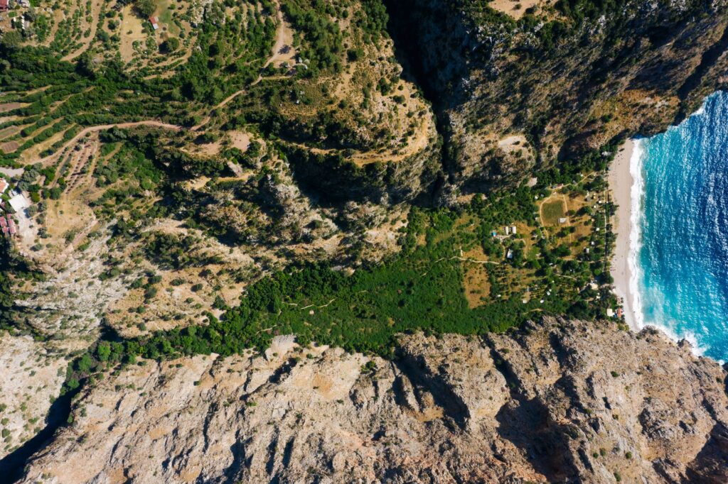
To comprehend the physical scale of the Lycian Way, one must analyze the geological nature of the Tekke Peninsula. The Mesozoic limestone rocks forming the western Taurus Mountains have undergone intense karstic dissolution processes, generating a three-dimensional relief characterized by sharp lapiaz, deep dolines, and vertical cliffs plunging directly into coves inaccessible by land. This geological structure explains the absence of permanent watercourses in mid and high altitudes, a critical factor conditioning water logistics for any hiker attempting the trail autonomously.
Along this natural corridor, the Lycians erected their fortified city-states, protected by the very inaccessibility of the terrain. Rock-cut necropolises carved into vertical faces, anthropomorphic sarcophagi emerging solitary among thyme thickets, and the remains of classical theaters oriented toward the marine horizon form an open-air museum accompanying the trekker at every turn. These are not mere isolated ruins, but an integrated cultural landscape where ancient bridle paths, locally known as patikalar, continue to serve as the sole pedestrian communication arteries between small rural enclaves along the coast.
Logistical Preparation and Seasonal Window Selection
The success of an integral traverse of the Lycian Way depends critically on the choice of seasonal timing. Summer months in southwestern Turkey are thermally extreme, routinely exceeding forty degrees Celsius in coastal areas with relentless solar radiation rendering the trail unusable between late morning and mid-afternoon. Consequently, the only viable temporal windows for undertaking the route safely and with thermal comfort are advanced spring—from late March to early June—and extended autumn—from mid-September through November.
During spring, the landscape undergoes an exceptional botanical explosion; arid slopes are covered with carpets of wildflowers, traditional wells still retain remnants of winter rains, and daytime temperatures hover optimally between twenty and twenty-five degrees Celsius. By contrast, autumn offers the advantage of a warm Mediterranean sea that invites physical recovery after long marching days, although accumulated water scarcity following summer demands even more rigorous planning regarding provisioning sources available in mountain villages.
Technical Equipment for Abrasive and Technical Terrain
The predominant surface types along the Lycian Way impose very specific demands on footwear and camping gear. The terrain is dominated by fractured limestone and loose scree, which severely punishes soft rubber soles and increases the risk of ankle sprains. Mid-cut boots with lateral reinforcements and high-traction Vibram-type soles are strongly recommended, complemented by telescopic poles equipped with wide baskets to prevent snagging in rock crevices.

blockquote>Footwear on the Lycian Way not only supports backpack weight but must endure the constant abrasion of limestone acting as natural sandpaper on seams and technical fabrics.
Textile gear must prioritize extreme breathability and broad-spectrum sun protection, avoiding heavy fabrics. Given that much of the route traverses exposed areas without arboreal vegetation, a wide-brimmed hat, category 3 or 4 sunglasses, and systematic application of high-SPF sun cream are as indispensable as the cartographic map itself. Additionally, backpacks should feature efficient compression systems to prevent load shifting during technical descents over loose terrain.
Water Management and Autonomy in Remote Sections
One of the greatest challenges hikers face on this itinerary is hydration. Unlike major mountain routes in northern latitudes, where snowmelt streams guarantee a constant supply, the Lycian Way runs across arid ridges and karstic plateaus where the only available water is found in local mosque cisterns, communal wells, or rural establishments run by local shepherds and farmers.
Carrying a minimum capacity of three liters of water per person is mandatory for mid-mountain stages, alongside a reliable filtration and chemical purification system, as rural cistern water may present microbiological contamination from seasonal livestock. Water solidarity with locals and absolute respect for private sources—which often rely on complex rainwater harvesting systems in rock-cut cisterns—constitute fundamental ethical rules to ensure coexistence within these rural communities.

Navigation and Cartography in the Coastal Labyrinth
Although the trail was initially waymarked following the European red-and-white paint marker system—known as Grande Randonnée (GR) blazes—the reality on the ground presents numerous discontinuities. Rock erosion, scree landslides, timber-logging access road construction, and local vandalism cause some markers to disappear at the most critical junctions.
For this reason, relying solely on visual markings is a tactical error that can lead to compromising situations. The combined use of updated topographic guidebooks, GPS devices with offline cartography, and 1:25,000 scale paper maps is essential. Knowing how to interpret contour lines within abrupt Lycian topography allows trekkers to anticipate key cliff passages and avoid erroneous descents into dead-end ravines.
Rural Accommodation and Route Self-Sufficiency
Support infrastructure along the Lycian Way has evolved significantly in recent years, enabling two distinct travel planning modalities: ultralight trekking with overnight stays in family-run guesthouses and small rural inns, or autonomous expedition style with tents and personal cooking gear.

Sleeping in villages such as Üçağız, Çıralı, or Faralya offers immersive exposure to Turkish rural hospitality, where local gastronomy—based on virgin olive oil, fresh vegetables, goat cheeses, and freshly baked bread—serves as an irreplaceable restorative element. Conversely, wild camping, while generally legal in wild areas away from protected archaeological sites, requires extreme caution with fire due to the high vulnerability of pine forests to wildfires.
Practical guide
How to get there: Dalaman International Airport (DLM) is the optimal access point for the western trailhead in Fethiye. For the eastern section or the finish in Antalya, Antalya International Airport (AYT) offers excellent connections to major European capitals.
Best time to visit: The months of April, May, October, and November offer the most stable climatic conditions, avoiding scorching summer heat and torrential winter rains.
Permits and regulations: No special access permit is required to hike the main trail, but strict camping and transit restrictions apply within archaeological zones protected by Turkey’s Ministry of Culture and Tourism.

Currency and payments: The official currency is the Turkish lira (TRY). Carrying cash in local currency is essential for small purchases in remote villages where card terminals lack network coverage.
Safety and emergencies: The general emergency number in Turkey is 112. Along steeper cliff sections, mobile phone coverage can be intermittent, so satellite communication devices are recommended for solo expeditions.
The Eternal Echo of Stones Over the Sea
As the sun begins to set over Cape Gelidonya, casting golden glints upon the solitary lighthouse keeping watch over the dangerous southern breakers, the trekker realizes that the true value of this traverse lies not solely in physical distance conquered, but in the capacity to attune with the ancient rhythm of a landscape where nature and history converse in silence. Every step on limestone rock, every whisper of wind through Calabrian pines, and every distant shimmer of the marine horizon reaffirm the foundational purpose of foot travel: inhabiting the space of memory with awakened senses and a steady stride.