Introduction to Vertical Isolation
The Musandam Peninsula, a geological promontory crowning the northernmost tip of the Sultanate of Oman and thrusting imposingly into the strategic Strait of Hormuz, represents one of the most fascinating and severe logistical challenges in the Middle East. Physically separated from the main body of Omani territory by a sovereign corridor belonging to the United Arab Emirates, this region of spectacular limestone fjords—known locally as khors—has historically turned toward the sea. The topography, characterized by limestone cliffs plunging vertically into crystal-clear waters and arid peaks exceeding two thousand meters in altitude, has for centuries prevented the consolidation of a conventional overland highway network. Today, Musandam’s connectivity is not merely a matter of tourism mobility, but a fragile umbilical cord sustaining the daily life of ancient fishing communities, small island enclaves, and a growing marine expedition industry.
Understanding how people, goods, and services move across this Arabian outpost requires examining a millimeter-precise intermodal network where the open sea, light aviation, and dirt tracks carved into living rock operate in permanent tension with the climate of the Persian Gulf and the Gulf of Oman. Unlike other desert enclaves where shifting sands dictate the pace, here the absolute protagonist is saltwater and the verticality of stone. From the provincial capital of Khasab to the secluded hamlets of Kumzar—accessible exclusively by sea due to their linguistic and geographic isolation—transport functions as a precision choreography where every link is vital to prevent regional supply collapse.
The Fjord Geography and the Primacy of Coastal Navigation
Musandam’s transport system has its backbone in the maritime routes plying the khors, of which Khor Ash Sham is the most celebrated and extensive. For decades, local fishermen used wooden vessels propelled by oars and lateen sails, known as dhows, to trade with Persian and Iranian ports situated across the strait. Today, although dhows still navigate the waters for tourism and minor coastal cabotage, heavy logistics and passenger transport rely on fleets of high-speed ferries and high-powered aluminum speedboats.
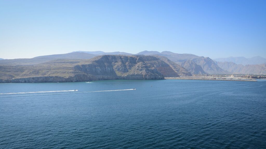
Oman’s national ferry company operates regular routes connecting the port of Shinas on the Batinah coast with Khasab and the remote locality of Limah. These vessels, capable of transporting both passengers and four-wheel-drive vehicles, bridge offshore distances that by land would require crossing multiple border checkpoints and desert traverses impractical for ordinary travelers. However, this maritime bridge is not without vulnerabilities. Seasonal northwest winds, known locally as the shamal, batter the strait violently during winter months, raising swells that force the suspension of crossings for days at a time, momentarily isolating the peninsula from the rest of the country.
On a micro scale, communities inhabiting the interior of the fjords depend entirely on outboard-powered speedboats. For a resident of Kumzar, the boat is not a leisure craft, but the sole available ambulance, the floating school bus, and the delivery truck for fuel and fresh provisions. This absolute reliance on coastal navigation turns local skippers into involuntary guardians of a liquid infrastructure requiring deep knowledge of tidal currents and underwater shoals.
Road Engineering in Rock: Corniche Roads and High-Altitude Tracks
If the sea dominates northern and eastern Musandam, the land offers a counterpoint of extreme engineering. Over the past decade, the Omani government has invested substantial resources in charting roads that defy gravity, connecting Khasab with the Jebel Harim highlands and interior plateaus. The paved road ascending from the coast to the peninsula’s highest peak is an exercise in astounding technical audacity: impossible hairpin bends, sustained slopes testing any vehicle’s cooling systems, and elevations exceeding fifteen hundred meters within a few kilometers.
Nevertheless, the true pulse of interior mobility is fought out on dirt and gravel tracks linking small settlements of seasonal herders and farmers. These routes, passable only by four-wheel-drive vehicles with low-range gearing, meander along ancient dry riverbeds—wadis—and cornices carved into sedimentary rock. Erosion caused by sudden flash floods—a meteorological phenomenon as scarce as it is violent in the region—regularly destroys entire sections of these pathways, demanding constant maintenance and repair operations by engineering brigades equipped with heavy machinery.
The true measure of distance in Musandam is calculated not in kilometers, but in the ability to read the tide, the condition of high-mountain asphalt, and the sudden fury of the shamal wind.
Maintaining these land infrastructures is extraordinarily costly due to the harshness of the environment. Extreme summer heat literally melts lower-grade asphalt compounds, while nocturnal thermal amplitude fractures limestone, periodically triggering rockfalls that block commercial and tourist routes into the interior.
Light Aviation as an Emergency Link
When stormy seas block the ferries and landslides cut mountain tracks, light aviation becomes the sole institutional lifeline. Khasab Airport, originally conceived as a strategic military installation due to its proximity to the Strait of Hormuz shipping lane, operates scheduled commercial passenger flights run by national carrier Oman Air, linking the provincial capital with Muscat.

This daily—or high-frequency weekly, depending on the season—air link is vital for public administration, urgent medical supply deliveries, and the movement of professionals sustaining the region’s educational and health services. Likewise, the presence of scattered helipads in the most inaccessible points of the fjords allows emergency medical evacuations from villages like Lima or Kumzar, where boat response would prove far too slow in critical health scenarios.
However, local weather once again imposes its limits. Morning mists descending from the peaks into coastal valleys and crosswinds generated by the abrupt mountainous topography require pilots to hold special ratings to operate at Khasab Airfield, considered one of the Arabian Peninsula’s most demanding aeronautical challenges due to the combination of rugged terrain and a short runway flanked by the sea.
Transport as an Engine of Ecotourism and Preservation
In recent years, Oman’s tourism development policy has embraced a low-impact model in Musandam, where transport plays a decisive role in conserving the fragile marine and terrestrial ecosystem. Traditional dhow excursions for spotting bottlenose dolphins and exploring coral reefs in Khor Ash Sham have been regulated through strict codes of conduct and vessel quotas to prevent overcrowding.

Access to the best diving and kayaking spots is managed via a network of authorized local operators employing fuel-efficient engine vessels and strict regulations regarding waste discharge. This transition toward responsible expedition tourism demonstrates that connectivity in Musandam seeks not only to move people efficiently, but to safeguard the delicate biological balance of an inland sea functioning as a natural nursery for numerous pelagic species.
- Coastal cabotage vessels and high-speed ferries serving as primary links between the north and the Omani coast.A network of off-road tracks essential for accessing traditional mountain settlements.Scheduled commercial flights and medical helicopter services guaranteeing civil safety.Strict regulation of tourist navigation to protect fragile fjord ecosystems.
Practical guide
Planning a journey and navigating across the Musandam Peninsula requires a rigorous understanding of its logistical and seasonal limitations. Below are the key aspects for structuring a safe and efficient itinerary in this frontier territory.
How to get there and main transport options: The most direct way to access Khasab from abroad is flying into Muscat International Airport and taking a connecting flight operated by Oman Air to Khasab Airport. Alternatively, driving from Dubai or Ras al-Khaimah (United Arab Emirates) across the Tibaat border post is possible; for this, holding valid multiple-entry visas and a cross-border vehicle insurance permit issued by the rental company is mandatory.

Vehicle rental and interior mobility: Exploring Musandam’s interior and ascending Jebel Harim strictly requires renting a four-wheel-drive vehicle (4×4) with low-range capabilities. Standard passenger cars are limited to urban asphalt and the main coastal highway. Checking tire pressure before tackling gravel tracks and carrying ample drinking water is strongly recommended, as service stations are scarce outside the urban hubs of Khasab and Dibba.
Navigation and maritime excursions: To tour the fjords and visit enclaves such as Khor Ash Sham or fishing hamlets, traditional dhows and motorized speedboats must be booked exclusively through official operators based in Khasab port. Checking local weather forecasts is essential to avoid setbacks caused by sudden onset shamal winds.
Silence Upon the Mirror of the Fjords
At dusk, as the sun sinks behind Mount Harim’s limestone ridges and the surface of Khor Ash Sham calms into a sheet of polished obsidian, the frenzy of daily logistics fades into solemn silence. At that precise moment, the traveler understands that Musandam’s true essence lies not in the complexity of its infrastructure, but in the silent obstinacy of those who have made this labyrinth of stone and water their home. The skippers returning to port with the last lights, the engines cutting their metallic roar, and the distant murmur of tides against cliffs remind us that, in this Middle Eastern outpost, survival and beauty depend upon a fragile, perfect balance between human ingenuity and the implacable vastness of the maritime desert.