At four thousand two hundred and twenty meters above sea level, the air does not merely thin; it acquires a mineral density that alters the acoustics of the physical world. On the La Polvorilla Viaduct, a sixty-three-meter-high filigree of curved steel suspended over the void of the Salta Puna, the train wheels produce a dry, metallic click that seems to vanish instantly into the desert expanse. Below, the dry bed of an Andean ravine rests motionless. Ahead, the horizon fractures into extinct volcanic cones stained with hues of ochre, sulfur, and lead. This final span of the famed Train to the Clouds represents one of the most audacious civil engineering achievements of the twentieth century in South America—a work that defied not only gravity and continental topography, but the physical endurance of the laborers who carved it with pickaxes and dynamite.
The Legacy of Richard Maury and the Genesis of the C-14 Branch
To understand the magnitude of this high-altitude rail journey, one must return to the 1920s. The original project of Branch C-14 of the General Belgrano Railway was conceived as an ambitious trans-Andean artery designed to link Argentina’s fertile Salta province with the Chilean port of Antofagasta, securing direct access for northwestern agricultural and mineral freight to Pacific shipping lanes. The task of designing a alignment capable of clearing the Andean massif without resorting to cog-and-rack systems fell to the American-born engineer Richard Fontaine Maury.
Maury devised a solution based purely on natural adhesion and elementary physics, enforcing a strict maximum gradient of two-and-a-half percent. To lift heavy trains from an elevation of 1,187 meters in Salta city to well over 4,000 meters across the high plateau, the track had to abandon straight lines entirely. Instead, it weaves through a hypnotic progression of zigzags, switchbacks, helical loops, and tunnels blasted directly through bedrock. Maury eliminated rack railways because he recognized that complex mechanical gear assemblies would drastically inflate maintenance demands in a remote, hostile environment where winter temperatures regularly plunge below minus twenty degrees Celsius.
Ascent Geography: From Cloud Forests to High-Altitude Desert
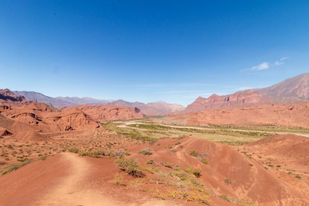
The journey through the Lerma Valley and the Quebrada del Toro showcases one of the most dramatic ecological transitions in the southern Andes. Over a distance of less than one hundred linear kilometers, the landscape shifts from the dense subtropical greenery of the Yungas cloud forest—where tree ferns, native walnuts, and laurels condense Atlantic moisture—to the stark austerity of the Puna biome, dominated by ancient cardon cacti, stunted tola shrubs, and saline crusts.
As the altitude climbs, the terrain’s chromatic palette alters radically. Lush greens yield to eroded cliffs of crimson sandstone, yellow clay veins, and volcanic talus slopes shimmering in shades of violet. This ecological gradient dictates human settlement patterns as well. Hamlets such as Campo Quijano, historically known as the Portal to the Andes, mark the boundary where the railway leaves the agricultural lowlands and enters the narrow gorge of the Toro River. Farther up, outposts like El Alisal and Chorrillos preserve the original switchback mechanisms that allowed locomotives to gain vertical clearance: trains enter a dead-end spur, switch the track point, and continue in reverse up the mountain face to the next bench.
La Polvorilla: The Anatomy of a Structural Feat
Formally opened to commercial traffic in 1948 after nearly three decades of intermittent construction, the La Polvorilla Viaduct stands as the indisputable structural masterpiece of the route. Spanning two hundred and twenty-four meters in length with a curve radius of two hundred meters, the 1,600-ton steel structure rests on six trestle pillars anchored into bare bedrock. Deliberately designed without solid side railings to minimize aerodynamic drag from fierce catabatic winds sweeping the Andean plateau, the bridge appears to float directly on the mountain air.
«The design of the C-14 line never attempted to conquer the Andes through brute force, but rather engaged in a dialogue with geological faults through exact, silent geometry.»
Standing aboard the train on the viaduct, the sensation of weightlessness is immediate. The diesel locomotive pauses for several minutes for technical inspection and passenger observation. At this altitude, the extreme dryness and intense solar radiation create an unforgiving visual clarity: the sky turns an ink-like cobalt blue, stripped of all ambient moisture haze, while cast shadows on the canyon floor reveal hyper-defined edges.
Life in the High Plateau Outposts: San Antonio de los Cobres
The operational and cultural center of this high plateau is San Antonio de los Cobres, a mining settlement steeped in Kolla indigenous heritage at 3,775 meters above sea level. Far from being a mere staging post for travelers, the town embodies the ancestral resilience of Puna communities. Mud-brick adobe houses with thatched roofs of wild straw and mud stand along wide, exposed streets where mountain gusts carry fine dust and the dry fragrance of burning tola and queñoa wood.
The regional economy has long revolved around mineral extraction and camelid pastoralism, yet the railroad fundamentally altered trade circuits throughout the twentieth century. At the station platform, local weaving cooperatives present textile work crafted on traditional looms from llama and vicuña wool: ponchos, ruanas, and heavy shawls colored with natural dyes derived from rock lichens, airampo seeds, and walnut husks. Commercial exchanges here proceed at a measured, dignified pace, untouched by the frenetic cadence of urban retail.
Modern Rail Operations: The Bimodal Format
To ensure consistent departure schedules and protect travelers from unpredictable seasonal washouts along the lower canyon, the modern excursion operates under a synchronized bimodal model. Travelers depart early in the morning from Salta’s historic railway terminal aboard dedicated overland coaches accompanied by professional guides, following National Route 51 parallel to the railway alignment.
This road journey allows for contextual stops at key geological and archaeological landmarks:
- Santa Rosa de Tastil: One of the most extensive pre-Inca urban ruins in northern Argentina, once home to over two thousand inhabitants in the fourteenth century.
- Alfarcito: A traditional mountain community dedicated to terraced agriculture, local crafts, and the preservation of heirloom Andean potato and maize varieties.
- Quebrada del Toro Lookouts: Natural viewpoints offering unobstructed perspectives on sheer geological folds and early cantilever railway bridges.
Upon arrival in San Antonio de los Cobres, passengers board the passenger consist. Hauled by specialized diesel-electric engines tuned to operate efficiently in low-density mountain air, the train traverses the final twenty-one kilometers across the open altiplano to La Polvorilla Viaduct, delivering travelers straight into the most dramatic sector of the Andean highlands.

High-Altitude Physiology: Managing Hypoxia
Ascending above 4,000 meters exposes the human body to a steep decline in barometric pressure and oxygen availability. Acute mountain sickness requires proactive physical management to prevent debilitating headaches, dizziness, and peripheral fatigue.
The train maintains certified medical staff and continuous medicinal oxygen systems in every car to treat sudden symptoms. However, proper acclimatization remains the primary defense. Seasoned travelers maintain deliberate hydration using mineral water and traditional infusions of coca leaf (Erythroxylum coca) or mountain chachacoma, avoid heavy meals and alcohol for forty-eight hours prior to departure, and move with deliberate slowness when disembarking at high-altitude stops. The traditional practice of chewing coca leaves—the ancestral acullico—remains a widespread and effective method across the Andes for alleviating early hypobaric discomfort.
Mineral and Geological Heritage of the Salta Puna
The terrain framing the C-14 railway is an open-air geological laboratory. The Puna is not a uniform plateau, but an endorheic basin fragmented by complex tectonic faults and bordered by stratovolcanoes surpassing 6,000 meters, including Mount Llullaillaco and Nevado de Acay. Immense salt pans and evaporite flats fill the intermontane troughs, evidence of ancient Pleistocene lakes that vanished over millennia.
Economically and scientifically, the region holds vital deposits of borates, lithium salts, copper, and sulfur. The historic operation of extraction sites like Mina Concordia provided the foundational justification for building this rail corridor. Today, interpreting the landscape requires recognizing the delicate balance between modern resource extraction, fragile desert hydrology, and the territorial heritage of indigenous communities who have stewarded these high valleys across centuries.
Practical Travel Logistics and Field Preparation
Planning a journey along the Ramal C-14 corridor requires thorough foresight due to limited capacity and high Andean weather dynamics.
- Optimal Season: The prime window spans from April to November during the dry winter season, when skies remain cloudless and the risk of seasonal flash floods affecting roads and rail infrastructure is negligible. June and July bring the sharpest sub-zero temperatures.
- Layering Strategy: A technical three-layer clothing system (moisture-wicking base, thermal fleece, and windproof shell) is essential. Diurnal temperature swings frequently exceed twenty-five degrees Celsius between sunny midday and early dawn.
- Sun Protection: UV radiation indices at elevations above 3,000 meters are severe. Category 3 or 4 UV-blocking sunglasses, broad-brimmed headwear, and broad-spectrum sunblock are non-negotiable necessities.
- Ticketing: Given worldwide interest and constrained train seat capacity, rail and bimodal reservations should be secured weeks in advance through authorized booking systems.
The Enduring Significance of an Andean Frontier
Traveling the length of the Ramal C-14 in the twenty-first century is far more than a scenic mountain excursion. It is an encounter with the collective memory of human grit set against one of the planet’s most formidable topographies. The drystone embankments raised block by block, the structural steel that continues to support thousands of tons across an abyss, and the echoing horn of the locomotive among the cliffs of the Puna remind us of an era when continental transport was measured by the audacity of engineering imagination.
This high-altitude railway journey remains an authentic, living chapter of South American history, uniting industrial heritage, indigenous cultural identity, and the timeless silence of the Andes.