Introduction to the Southern Channels of Chilean Patagonia
The labyrinth of channels, fjords, islands, and archipelagos that makes up western Chilean Patagonia represents one of the most challenging, indomitable, and fascinating navigation settings on the planet. From the Reloncaví estuary to the confines of Cape Horn, the southern coastline unfolds as a complex geological system where the Andes mountain range plunges directly into the Pacific Ocean. This abrupt topography has created a historical refuge for seasoned sailors, artisanal fishermen, and expeditioners seeking to understand the true magnitude of the southern marine wilderness. Among this network, the routes meandering around the Guindas archipelago, the channels of the Gulf of Penas, and the approaches to the San Rafael Glacier demand an absolute mastery of coastal and open-water seamanship, as well as a reverential respect for the whims of Patagonian weather.
Understanding this maritime territory requires abandoning any conventional notion of coastal navigation. Here, distances are measured in hours of autonomy, nautical cartography must be complemented by an attentive empirical reading of tides and winds, and self-sufficiency ceases to be a mere recommendation to become the sole guarantee of survival. This report offers a technical and cultural immersion into the planning of nautical traverses through the Patagonian channels, analyzing currents, natural refuges, changing meteorology, and the port logistics indispensable for any expedition daring to challenge the great south.
Geography and Oceanographic Dynamics of the Southern Pacific
The morphology of the Patagonian channels is the direct result of glacial erosion during past ice ages. The submerged valleys gave rise to deep channels, often exceeding one thousand meters in depth, flanked by vertical rock walls where evergreen forests—such as coigüe, tepú, and canelo—cling with impossible slopes. This submarine and terrestrial configuration generates a very particular hydrodynamic behavior, where tidal currents can reach speeds of several knots in narrow passages, known locally as tidal gates or channels.

Added to this geometric complexity is the direct influence of the Antarctic Circumpolar Current and frontal systems advancing uninterruptedly from the west. The region lies under the domain of the ‘furious fifties,’ a latitudinal band characterized by persistent westerly winds that collide head-on with the Andean cordillera. This collision causes almost constant precipitation and extreme weather variability, where clear skies and calm seas can transform into hurricane-force storms in a matter of minutes. The navigator must command robust vessels, preferably displacement hulls, equipped with redundant steering systems and solid swinging capacity in anchorages.
Route Planning and Autonomy in Remote Waters
Planning a nautical expedition through the Guindas archipelago and surrounding channels requires meticulous rigor. Unlike commercial routes or mass tourist circuits, supporting infrastructure here is practically nonexistent outside of a few ports of call like Puerto Edén, Caleta Tortel, or Puerto Raúl Marín Balmaceda. This means every vessel must set sail with total autonomy in fuel, fresh water, provisions, and critical spare parts to cover weather contingencies that can prolong a voyage for days or weeks.
Fuel autonomy calculation is the Achilles’ heel of any journey in Patagonia. Headcurrents and front winds drastically reduce effective advance speed and multiply engine fuel consumption. Therefore, routes must be designed by optimizing favorable tidal windows and taking advantage of natural shelters offered by the lee coasts of islands. Official cartography, provided by the Hydrographic and Oceanographic Service of the Chilean Navy (SHOA), is the fundamental tool, though it must be complemented by updated sailing directions and the local experience of Chilotan and Patagonian mariners.
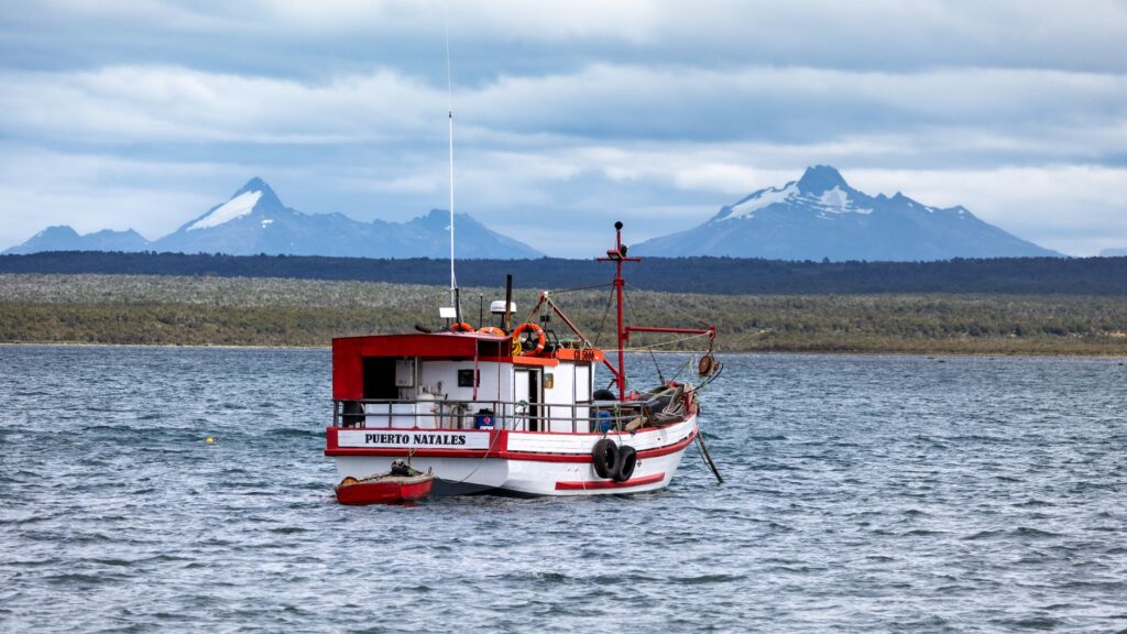
The southern sea admits no improvisations; every mile sailed in the channels is a constant dialogue between the vessel’s endurance and the fury of the elements.
Similarly, satellite communication systems and daily weather bulletins issued by the maritime authority are indispensable. Although cellular signal is nonexistent across the vast majority of the route, VHF and HF radio equipment allows constant contact with port captaincies and early reception of deep frontal systems warnings that force immediate shelter-seeking.
Extreme Meteorology and Frontal Systems in Southern Chile
Patagonian weather is famous for its proverbial instability, but sailors operating in the Guindas archipelago know that reality far surpasses reputation. The region experiences the interaction of three main air masses: marine polar, Pacific subtropical, and circumpolar depression. This confluence generates a rapid succession of low-pressure systems crossing the ocean from west to east, bringing warm fronts followed by cold fronts laden with hail, snow, or horizontal rain driven by violent gusts.
One of the most dangerous phenomena for channel navigation is katabatic winds, regionally known as willywaws. These winds originate when cold air accumulated over the Patagonian ice fields descends swiftly down the fjord slopes, striking the water with devastating force capable of knocking down sailboats or tearing away superstructures. To mitigate this risk, skippers must meticulously study the topography of anchorages, avoiding bays open to prevailing winds and preferring those with good mud or sand holding grounds protected by high cliffs.

The Art of Anchoring and Natural Refuges in the Channels
In an environment where formal docks and piers are absent, selecting and executing anchoring maneuvers is the most critical task of the seafaring day. Patagonian channels are characterized by abyssal depths even very close to the shore, making it difficult to find adequate platforms for anchoring with recommended scope ratios (typically three to five times the depth). For this reason, traditional seamanship in the area includes the use of shore lines.
This technique involves dropping the main anchor in the central pool of a cove and deploying one or two long stern lines to sturdy trees on firm land, immobilizing the vessel to prevent free swinging during wind direction shifts. Chosen trees must be carefully inspected; old coigües and alerce trees offer secure tie-off points if tree-trunk protectors are used to prevent bark damage. Mastering this maneuver allows crews to spend the night with peace of mind while outside in the main channel, the storm rages mercilessly.

The Life and Seafaring Culture of Southern Communities
Navigating the Guindas archipelago is not only an exercise in nautical skill but also an encounter with a culture deeply rooted in the sea. Historically, canoe-faring peoples like the Chono and Kawésqar populated these channels, voyaging in fragile bark canoes and adapting perfectly to a hostile environment. Today, descendants of Chilotan settlers and artisanal fishermen keep that tradition alive, inhabiting isolated coves where the only communication and supply line is the sea.
Localities like Puerto Edén, situated at the northern end of the Edén Channel, are living examples of this cultural resilience. Their wooden walkways suspended over water replace traditional streets, and inhabitants depend on passing state ferries or small boats to receive medical supplies and fresh food. For the contemporary expeditioner, sharing a few hours with these communities provides an invaluable perspective on the true meaning of living in harmony with the southern environment, reminding us that respect for surroundings is the only key unlocking the doors of Patagonia.
Practical Information for Navigation and Expedition Logistics
Planning a nautical traverse in southern Chile requires complying with strict regulations enforced by the General Directorate of Maritime Territory and Merchant Marine (DIRECTEMAR). Every vessel entering jurisdictional waters must submit an official departure clearance (zarpe), detailing the planned route, crew roster with respective nautical qualifications, and safety equipment inventory including self-inflating life rafts, 406 MHz EPIRBs, immersion suits, and duplicated electronic navigation systems.

- Recommended Season: The austral summer months, from December through March, offer the best meteorological conditions, with longer days, lower storm frequencies, and air temperatures hovering around 10°C to 15°C (50°F to 59°F).
- Authorizations and Clearances: Daily check-ins are mandatory with the port captaincy of the respective jurisdiction (such as Castro, Aysén, or Puerto Natales) via VHF radio or satellite phone, reporting current position and route forecasts.
- Fuel and Supplies: Marine diesel fueling points are very scarce. The last reliable gas stations are found in Quellón, Puerto Aysén, and Puerto Chacabuco to the north, and Puerto Natales to the south.
- Mandatory Safety Equipment: Beyond standard gear, paper nautical charts as backups, adjusted magnetic compasses, waterproof marine binoculars, and spare anchors with high-strength rove lines are required.
True marine exploration in Patagonia does not measure its success by travel speed, but by the ability to return to tell the tale with an intact crew and unwavering respect for the sea.
Visual Conclusion and Reflection on Patagonian Immensity
When the traverse comes to an end and the vessel makes a safe port call, the predominant sensation is a profound mixture of humility and awe. The Guindas archipelago and Patagonian channels are not a conventional tourist destination; they are a geological sanctuary where humans once again become conscious of their fragility before the immensity of the ocean and mountains. Dark deep waters, the silent flight of albatrosses following the ship’s wake, and the majesty of glaciers descending toward the sea compose a timeless tableau etched indelibly into the memory of anyone daring to navigate them.
In an era where technology promises to master every corner of the planet, maritime Patagonia remains that wild bastion where nature’s laws rule without discussion. Preserving this pristine territory, respecting its cycles, regulations, and fragile marine ecosystems, is an inescapable responsibility for any navigator aspiring to be a worthy guest of the channels at the end of the world.