The Alto Douro in Portugal is a territory where farming and geography have been negotiating for two thousand years. On the slopes falling towards the Douro River and its tributaries, generations of growers built terraces with schist walls to hold soil and water on gradients that in places exceed forty degrees. What is now admired as a landscape of outstanding beauty is, in fact, a working agricultural infrastructure, maintained by hand and adapted over centuries.
UNESCO inscribed this wine region on the World Heritage List in 2001, recognising not only the antiquity of production — some two thousand years according to official documentation — but the technological, social and economic evolution imprinted on the land. Since the 18th century, Port wine, whose quality was defined and regulated from 1756, turned this valley into a globally traded product. To travel through it today means looking beyond the viewpoint and asking who literally holds up the walls that support the landscape.
A valley shaped by necessity, not by aesthetics
World Heritage documentation describes how the Douro River and its main tributaries — Varosa, Corgo, Távora, Torto and Pinhão — form the backbone of a mountain landscape sheltered from harsh Atlantic winds by the Marão and Montemuro ranges. On that geological base, terraces cover some 24,600 hectares. They are not ornamental: they are the practical answer to a concrete problem, how to farm on slopes where soil slips and water runs away.
Different systems were tested over the centuries. The earliest, used before the phylloxera plague that devastated European vineyards around 1860, was that of the socalcos: narrow, irregular terraces buttressed by schist stone walls, where only one or two rows of vines could be planted. That system required continuous maintenance, because every wall had to be repaired after heavy rain.

After phylloxera, in the late 19th and early 20th centuries, the vineyards were rebuilt with longer, more regular and slightly sloping terraces, which allowed better sun exposure and made work easier. Official documentation notes that these continuous lines altered the landscape not only because of the monumental walls but also because they changed how people farmed and moved across the slopes.
The Alto Douro landscape is the visible consequence of permanent observation, local testing and a profound knowledge of how to adapt the vine to extremely unfavourable conditions.
Pinhão and the river as the axis of daily life
Pinhão, in the municipality of Alijó, is one of those places where the relationship between the river and daily life becomes evident. Located at the confluence of the Douro and the Pinhão River, the town serves as a reference point for travellers wanting to grasp the scale of the valley. Its historic quay and its railway station, known for the tile panels depicting harvest scenes, have for decades been departure and arrival points for people, grapes and goods.
There is no need to invent anecdotes to describe life here: observing how the territory is organised is enough. White-walled villages and casais — small family holdings — are usually located halfway up the valley sides, around a parish church that often dates from the 18th century. Streets are narrow and winding, and vernacular architecture has been preserved with notable examples of adaptation to climate and terrain.
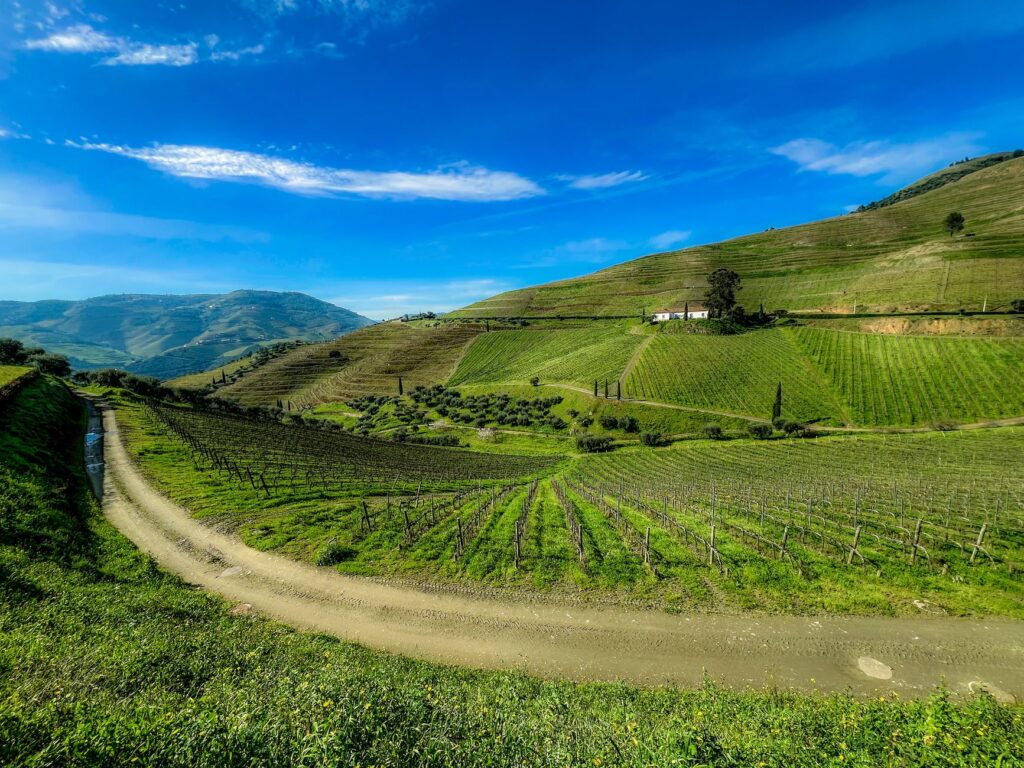
Higher up, quintas — large wine-producing estates with a main house, wineries and farm buildings — can be identified from a distance by their clustered structures. World Heritage documentation highlights them as major landmarks, especially in the Upper Corgo and Upper Douro. Between them, small chapels dot the hills, sometimes next to manor houses, sometimes high up, visible from the roads.
A collective work with no known author
One of the most suggestive aspects of this landscape is that it responds to no single plan or identifiable author. UNESCO describes it as the outcome of the acumen and determination of anonymous people who, over generations, learned to read the cycle of water and materials to build a system of terraces supported by schist walls. It is, in a sense, a collective territorial artwork, made without a signature and maintained through continuous effort.
That condition has practical consequences. Conservation depends not only on administrations but on the daily work of those who farm. The Portuguese state has developed planning instruments, such as the Intermunicipal Spatial Plan for the Alto Douro, approved in 2003, and has created specific management structures, such as the Douro Mission in 2006, whose objectives include enhancing, preserving and safeguarding the landscape. The documentation itself acknowledges that the large buffer zone, covering 225,400 hectares, poses management difficulties.
Concerns listed include the conservation and rehabilitation of schist walls and socalcos, the adaptation of planting methods, the creation of tree networks to divide vine fields and provide passageways, the minimisation of visual intrusions, the protection of vernacular heritage and the regulation of new buildings. These are technical matters, but they directly affect the experience of anyone travelling through the valley.

What you see along the Douro roads
Travellers heading up from Pinhão towards higher ground discover a diverse mosaic. Not everything is vineyard: orange groves, sometimes walled, appear near watercourses, while scrub, small woods and cultivated plots alternate at higher altitudes. The documentation describes this ensemble as a mosaic of crops, groves, watercourses, settlements and agricultural buildings arranged as quintas and casais.
The best-known viewpoints offer broad panoramas, but the real scale of the work is better perceived on secondary roads, where walls can be seen up close and it becomes clear how much labour their maintenance requires. In some places, visitors can observe stone channels that once collected runoff water, a catchment system adapted to terrain that loses moisture quickly.
The region has been producing wine for around two thousand years and its landscape has been moulded by human activity; terraces, quintas, villages, chapels and roads are representative of the full range of activities associated with winemaking.
Wine as a thread, not the only argument
Port wine is undoubtedly the product that brought this region worldwide fame from the 18th century onwards. But reducing the Alto Douro to a denomination of origin would miss the essential point. The landscape is also an archive of farming techniques, forms of ownership, social organisation and beliefs. Chapels, roads, walls and houses tell a broader story than that of the wine trade.

World Heritage documentation insists that the landscape is still profitably farmed in traditional ways by traditional landholders, and that its authenticity has been maintained because function has driven conservation. In other words, walls have been repaired because they were needed, not because someone decided to turn them into a museum piece. That is perhaps the key to its vitality.
For the responsible traveller, the consequence is clear: this territory should be approached with respect, as it is both a protected landscape and a workplace. Roads are narrow, access to estates is private and farming follows its own calendar. Observing without interfering, hiring local services and choosing small accommodation are concrete ways of helping this balance endure.
Landscape and daily life: a relationship learned on foot
The relationship between landscape and daily life in the Alto Douro cannot be understood from a single viewpoint. It requires time, movement and attention to detail. Walking the paths that connect villages, pausing in squares where agricultural products are dried or listening to water in the stone channels reveals the human dimension of a territory often photographed as if it were an empty stage.
Depopulation is a real challenge in many rural areas of inland Portugal, and the Alto Douro is no exception. Official documentation mentions the need to enhance settlements and maintain a sustainable economy. Well-managed tourism can help retain population and fund wall maintenance, but it can also create pressures. The key lies in scale and respect for local rhythms.

Practical guide
Before planning a trip to the Alto Douro, it is worth considering some practical matters that help travellers explore the region with judgement.
Getting there and getting around
- Pinhão has a railway station on the Douro line, connecting the region with Porto and other towns in the valley. The train is a convenient way to arrive without depending on a car.
- Secondary roads are narrow and winding; drive cautiously and allow more time than the distance on the map suggests.
- Signposted viewpoints have limited parking; in high season, setting off early helps avoid crowds.
What to visit with judgement
- Quintas and wineries usually require advance booking for visits and tastings. Not all are permanently open to the public.
- Mid-slope villages such as Provesende or Favaios allow visitors to observe vernacular architecture and territorial organisation without entering private property.
- Chapels and parish churches are part of religious and cultural heritage; respect opening hours and access rules.
When to travel
- Spring and autumn offer milder temperatures and favourable light for exploring the valley.
- The grape harvest, in late summer and early autumn, is a time of intense farming activity; it can be interesting to observe, but it means more traffic and movement on the estates.
- Winter is colder and wetter, but also quieter for those seeking silence and lower prices.
Responsible visiting tips
- Do not enter vineyards or estates without permission; they are private working spaces.
- Respect the stone walls and do not climb on them; they are fragile structures requiring constant maintenance.
- Spending in local businesses and staying in small establishments contributes to the local economy.
- Carry water and wear suitable footwear if walking rural paths; shade is scarce on many slopes.
A landscape held up by hands
At the end of the journey, what remains is not only the image of terraces turning gold at sunset. What remains is the awareness that this landscape exists because someone, every day, checks a wall, clears a channel or prunes a vine. The grandeur of the Alto Douro lies not only in its beauty but in its fragility, sustained by work. Understanding this changes the way we look at it and, above all, the way we visit it.