


It rises from the expanse of the Pacific Ocean like an emerald basalt fortress, lashed by near-constant squalls and encircled by abyssal depths plunging past four thousand meters. Situated 550 kilometers southwest of mainland Costa Rica, Cocos Island is the sole emerged summit of the volcanic Cocos Ridge. Its geographic isolation is no mere tectonic quirk; it forms the core of one of the planet’s most productive, dynamic, and complex marine biological systems.
Beneath its turbulent surface, colliding equatorial currents transform this remote perimeter into a global crossroads for pelagic megafauna. Understanding Cocos Island demands a deep dive into an intricate matrix of geological drivers, upwelling dynamics, and transboundary migratory routes that defy traditional geopolitical borders in the Eastern Tropical Pacific.
Volcanic Genesis and the Oceanographic Crossroads of the Eastern Pacific
The geological history of Cocos Island is inextricably tied to the movement of the Cocos Plate over the Galápagos volcanic hotspot. Between 1.5 and 2.5 million years ago, repeated submarine basaltic eruptions piled layers of lava and pyroclasts until they breached the ocean surface. The surrounding submarine topography forms an intricate maze of abyssal canyons, razor-sharp pinnacles, and submerged seamounts that fundamentally alter regional hydrodynamics.
This underwater relief acts as a physical barrier against prevailing oceanic currents. The North Equatorial Countercurrent, pushing warm water eastward, collides head-on with the underwater slopes of the ridge, interacting with branches of the Humboldt Current and nutrient-dense deep water masses. This hydrodynamic collision triggers localized upwelling events, thrusting nitrates, phosphates, and silicates from the aphotic zone up into the sunlit epipelagic layer.
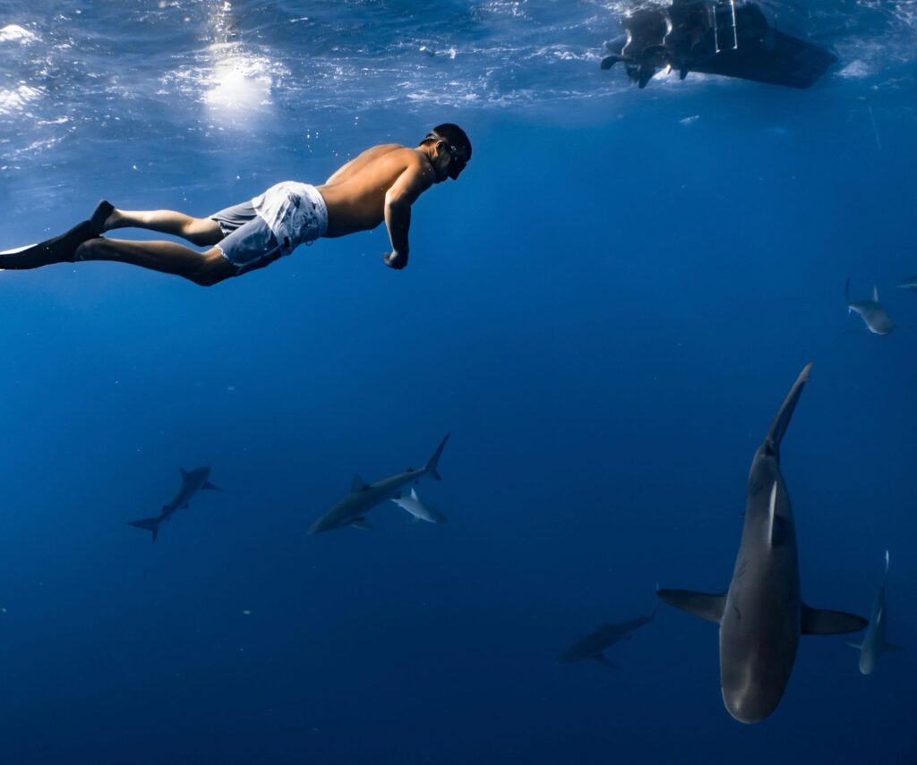
The immediate consequence of this continuous fertilization is an explosion of primary productivity. Phytoplankton blooms support colossal masses of zooplankton, which in turn sustain vast shoals of baitfish, including jacks, snappers, and sardines. In the waters of Cocos Island, the marine food web operates as an inverted trophic biomass pyramid, where apex predators numerically and visually dominate the ecosystem.
«The seamounts of Cocos function as energetic beacons across an apparent oceanic desert, concentrating pelagic biomass on a scale unmatched in the Western Hemisphere.»
The Dance of the Hammerheads: Biology and Ethology of Sphyrna lewini
No biological spectacle defines the scientific prominence of Cocos Island more distinctly than the massive aggregations of the scalloped hammerhead shark (Sphyrna lewini). While most apex elasmobranchs maintain solitary lives, hammerheads around Cocos assemble during daylight hours into schooling formations numbering in the hundreds, orbiting oceanic pinnacles such as Bajo Alcyone, Submerged Rock, and Dirty Rock.
These massive schools assemble around these underwater spires due to several critical ecological and physiological drivers:
- Cleaning stations: Submerged volcanic pinnacles harbor dense populations of barberfish (Johnrandallia nigrirostris) and King angelfish (Holacanthus passer). The hammerheads adopt head-up postures and slow their pace, allowing these small teleosts to pick off parasitic copepods and isopods from their dermis, gills, and mouth cavities.
- Geomagnetic navigation: The basaltic rocks of the seamounts, rich in iron and magnetic minerals, create measurable geomagnetic anomalies. Scalloped hammerheads use their ampullae of Lorenzini to read these magnetic pathways, navigating with extraordinary precision when departing on nocturnal feeding excursions into open water.
- Social interaction and thermoregulation: Remaining in warmer, well-oxygenated surface waters during the day helps the sharks recover metabolic equilibrium after spending the night hunting deepwater squids in cold sub-thermocline depths.
Acoustic and satellite telemetry tracking conducted by marine biologists from research consortiums such as MigraMar has demonstrated high site fidelity to specific underwater reefs, confirming that the island serves as a vital daytime sanctuary before these predators disperse into the surrounding abyss under cover of darkness.

Seamounts as Oases of Pelagic Nutrition
Beyond the pinnacles directly flanking the main island, the Cocos Ridge extends for hundreds of kilometers toward the southwest. Across these submerged summits that never break the ocean surface, pelagic biodiversity reaches staggering concentrations. These underwater peaks act as biological retainers for species that would otherwise drift diffusely through the ocean void.
At legendary dive sites like Bajo Alcyone, which ascends from deep ocean floor to within 25 meters of the surface, megafauna interactions are relentless. Beside the hammerhead schools, resident populations of whitetip reef sharks (Triaenodon obesus) pack into volcanic ledges by day before embarking on synchronized group hunts across the reef substrate at dusk, transforming the seabed into a churning carpet of predators.
To this dynamic matrix are added transient ocean giants. Whale sharks (Rhincodon typus), silky sharks (Carcharhinus falciformis), tiger sharks (Galeocerdo cuvier), and massive aggregations of giant oceanic manta rays (Mobula birostris) converge on these bathymetric peaks to exploit upwelling currents, feeding with minimal energetic cost.
The Submarine Highway: Biological Connectivity With Galápagos and Malpelo
Cocos Island does not function in ecological isolation. It is a critical hub within the Eastern Tropical Pacific Marine Corridor (CMAR), a multilateral network of marine protected areas connecting Costa Rica’s Cocos, Ecuador’s Galápagos Archipelago, Colombia’s Malpelo and Gorgona sanctuaries, and Panama’s Coiba National Park.
Extensive satellite tagging of highly migratory marine species has definitively mapped the Cocos-Galápagos Swimway. This underwater corridor is used seasonally by pregnant female hammerhead sharks, leatherback sea turtles (Dermochelys coriacea), green sea turtles (Chelonia mydas), and cetaceans navigating between pelagic feeding hotspots and continental mangrove nurseries.

This connectivity extends beyond megafauna migrations to genetic and oceanographic exchanges. The larvae of stony corals, reef-associated fishes, and benthic crustaceans drift across open-ocean gyres, ensuring robust gene flow between isolated island groups and enhancing the ecological resilience of reefs in the face of major climate shocks, such as El Niño-Southern Oscillation (ENSO) events.
«Guarding an isolated island perimeter is futile if migratory pelagics are culled in adjacent international waters; marine conservation must operate across entire oceanic basins.»
Cloud Forests Over the Abyss: Terrestrial Endemism in Isolation
While Cocos Island’s global reputation centers on its marine life, its 24 square kilometers of emerged landmass showcase an equally remarkable terrestrial ecosystem. It is the only oceanic island in the Eastern Tropical Pacific that supports a true cloud and pre-montane tropical rainforest, sustained by annual rainfall exceeding 7,000 millimeters.
Towering sea cliffs, carved by countless waterfalls plunging directly into the ocean, are cloaked in dense vegetation dominated by the endemic tree Sacoglottis holdridgei, massive tree ferns, and hanging epiphytes. Extreme isolation has driven intense adaptive radiation across native terrestrial fauna:
- Endemic land birds: Three species exist nowhere else on Earth: the Cocos flycatcher (Nesotriccus ridgwayi), the Cocos cuckoo (Coccyzus ferrugineus), and the Cocos finch (Pinaroloxias inornata), a member of the famed Darwin’s finch group.
- Reptiles and invertebrates: Endemic lizards such as Townsend’s anole (Anolis townsendi) and the Cocos gecko (Sphaerodactylus pacificus) thrive alongside dozens of unique invertebrate species.
- Land-sea nutrient cycling: Vast colonies of breeding seabirds, including red-footed boobies (Sula sula), white terns (Gygis alba), and great frigatebirds (Fregata minor), deposit thousands of tons of marine-derived guano into the forest soil, fueling terrestrial growth and closing the ecological loop between land and sea.
Governance, Illegal Fishing, and High-Seas Satellite Surveillance
The extraordinary marine biomass around Cocos Island has made it an enduring target for commercial longliners and purse-seine tuna fleets operating illegally on the margins of its territorial waters. Pelagic longlining, with lines spanning tens of kilometers and bearing thousands of baited hooks, remains the greatest threat to sharks, sea turtles, and billfish.

In December 2021, Costa Rica enacted a landmark decree that expanded Cocos Island National Park’s fully protected no-take marine reserve from 2,000 km² to nearly 54,000 km², while simultaneously establishing the Bicentennial Marine Managed Area, encompassing an additional 106,000 km² with stringent fisheries controls.
Enforcing protection over an oceanic expanse of this scale relies on sophisticated modern technology. The National System of Conservation Areas (SINAC) ranger corps, supported by the Friends of Cocos Island Foundation (FAICO) and platforms like Global Fishing Watch, utilizes Vessel Monitoring Systems (VMS), Automatic Identification Systems (AIS), land-based radar at Chatham Bay, and continuous joint patrols with the National Coast Guard Service to intercept illegal incursions.
Practical guide
Access, Expedition Logistics, and Accommodations
Cocos Island is an uninhabited national park with no hotels, roads, or commercial airstrips. The sole method of access is aboard specialized liveaboard dive vessels departing from the port of Puntarenas on Costa Rica’s Pacific coast. Crossing 550 kilometers of open ocean typically takes between 32 and 36 hours of non-stop navigation each way.
Diving Experience and Profile Requirements
Due to strong oceanic currents, open-ocean blue-water descents, and extreme isolation, authorities and operators require divers to hold at least an Advanced Open Water Diver certification with a verified log of at least 50 open-water dives. Proficiency with surface marker buoys (SMB) and current diving is mandatory. Enriched Air Nitrox is virtually required on all expeditions to maximize allowable bottom time and manage nitrogen loading. Water temperatures range between 23°C and 29°C (73°F to 84°F), though sudden thermoclines can drop temperatures to 18°C (64°F) below 20 meters.

Climate and Seasonal Variations
Diving expeditions operate year-round, but distinct seasons offer contrasting ecological and surface conditions:
- Rainy season (June to November): Stronger upwelling brings maximum concentrations of pelagic life, including peak schooling hammerhead aggregations and manta encounters. Surface seas are generally rougher, with underwater visibility averaging 10 to 20 meters.
- Dry and transitional season (December to May): Calmer sea conditions provide smoother crossings and underwater visibility often reaching 30 meters. Pelagic species remain abundant but may hold deeper along the thermocline.
Park Regulations and Environmental Stewardship
Strict conservation laws govern the marine reserve: touching the reef, landing ashore without park ranger escorts, using non-authorized gloves or reef hooks, and collecting any biological or mineral specimens are strictly forbidden. Visitors pay mandatory daily park conservation fees that directly fund ranger operations, radar maintenance, and ongoing telemetry research programs.
The Pulse of the Wild Ocean
Hovering motionless in the deep blue off Cocos Island, watching a hundred hammerhead sharks glide in synchronized formation over a submerged volcanic spire, is one of the world’s most humbling encounters with wilderness. It offers a rare, pristine glimpse into how Earth’s oceans functioned before industrial fishing emptied open waters of their apex predators.
Preserving this remote outpost does not rest solely on the dedicated rangers and researchers stationed in the wet isolation of Chatham and Wafer Bays. It hinges on the global resolve to champion transboundary ocean conservation, ensuring that the pelagic highways sustaining life across the Eastern Pacific remain unbroken for generations to come.


