The Dark Waters of Lough Leane and the Persistence of Wood
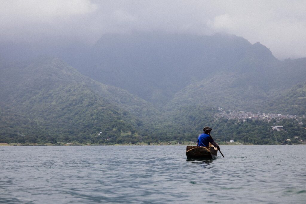
The air on the eastern shore of Lough Leane, the largest of the three lakes forming the Killarney system in County Kerry, smells perpetually of damp peat and decaying moss. In the early morning hours, before Atlantic breezes dissipate the mist rolling down from the peaks of Macgillycuddy’s Reeks, the water’s surface remains perfectly glassy, adopting the dark hue of strong tea. It is at this exact moment that local boatmen prepare their traditional open boats—wooden vessels powered by ash oars and low-horsepower outboard motors that defy modernity with silent resilience. This fluvial infrastructure does not conform to contemporary mass transit standards, but rather to an unbroken historical continuity stretching back to the O’Donoghue clans and the monks who inhabited the ruins of Innisfallen Island in the seventh century.
Navigating these freshwater mirrors demands absolute mastery of local bathymetry, marked by submerged limestone ledges and shifting sandbanks sculpted by glaciers more than ten thousand years ago. The captains, whose families have manned these oars for generations, read the currents by observing the alignment of reeds and the behavior of ospreys. Unlike conventional commercial routes, transit across the Killarney lakes—linking Lough Leane, Muckross Lake, and the Upper Lake—operates under a delicate ecological equilibrium. Government restrictions protecting the habitat of native red deer and ancient Atlantic oak forests limit fleet sizes, turning every crossing into a living lesson in respect for geographic isolation and the fragility of Ireland’s natural environment.

Glacial Engineering and the Gap of Dunloe Gorge
The lacustrine journey does not terminate at the shoreline; rather, it culminates in an abrupt topographical transition known as Lord Brandon’s Cottage, at the head of the Upper Lake. Here, the fluvial navigation system gives way to the overland track winding upward toward the Gap of Dunloe gorge. This mountain pass, a U-shaped canyon carved by glacial erosion, acts as the terrestrial counterpart to the boat journey, uniting the southern river basins with the hidden valleys of western Kerry. The logistical coordination between boatmen and the drivers of traditional pony-drawn jaunting cars constitutes an integrated mobility system that has remained virtually unaltered since the Victorian era.
Analyzing the geomorphology of this corridor reveals why water transport remains indispensable in Killarney. The roads bordering the lakes are narrow, winding, and protected by strict environmental regulations banning heavy traffic and tour buses from the heart of the national park. The lake ferry thus serves as a vital artery absorbing the flow of travelers without disrupting the integrity of the landscape. During autumn and winter months, when rainfall swells water levels and southwest gales lash the red sandstone cliffs, boatmen adjust their schedules to daylight hours, demonstrating that the survival of these routes depends on constant adaptation to the caprices of the Atlantic climate.

Monastic Architecture and the Legacy of Innisfallen
Floating upon the waters of Lough Leane, Innisfallen Island emerges as a tangible testament to how geographic isolation fostered the cultural development of medieval Europe. The monastery founded in 640 AD by Saint Finian the Leper was not merely a spiritual sanctuary, but an intellectual hub of the highest order where the celebrated Annals of Innisfallen were compiled—one of the most important chronicles of early Irish history. For the monks, the lake functioned simultaneously as a defensive moat and as the sole communication route with the outside world via crude skiffs carved from elm trunks.
The conservation of this architectural heritage is intrinsically linked to the logistical limitations of water transport. Lacking bridge connections or roads, any restoration work on the ruins requires traditional cargo barges to transport building materials, tools, and conservation experts without damaging the delicate flora blanketing the island. This titanic effort underscores the interdependence between maintaining navigation infrastructure and historic preservation. Every vessel docking at Innisfallen’s limestone pier perpetuates an umbilical cord that has nourished the collective memory of southwestern Ireland for a millennium.

The Biodiversity of the Atlantic Oak and the Microclimate
The ecosystem surrounding Killarney’s lake basin possesses unusual subtropical characteristics for Ireland’s latitude, a phenomenon driven by the direct influence of the Gulf Stream and the natural shelter provided by surrounding mountains. Native oak woods, considered the last remnants of the great primeval forests covering the island before extensive agriculture, blanket the slopes descending directly into the water. Silently navigating the narrow channel uniting Muckross Lake with the Upper Lake reveals branches draped in moss and shaggy ferns arching over the vessel’s bow, creating an almost impenetrable vegetal tunnel.
This delicate biological balance is directly influenced by regulations governing fluvial and lacustrine transport. Killarney National Park authorities strictly oversee combustion engine emissions and vessel drafts to prevent shoreline erosion and the introduction of invasive species threatening endemic flora, such as the strawberry tree and various Atlantic fern varieties. The result is a mobility model where the traveler is not a mere consumer of landscapes, but a passive witness to an ecological sanctuary that self-protects through its very terrestrial inaccessibility.

Water in Killarney is not an obstacle to be crossed, but a living archive where Ireland’s geological history and monastic memory float in complete stillness.
The Traditional Economy of Boatmen and Oral Transmission
Behind every crossing on the Killarney lakes lies a complex network of traditional trades resisting obsolescence in the twenty-first century. The boatmen, organized into informal yet rigorous associations, pass down the secrets of rowing navigation, the joinery required to repair ash and oak ribs, and a vast repertoire of local legends recounting tragic romances and clan battles permeating every cove and headland. This oral transmission constitutes an intangible heritage as valuable as the stone monuments dotting the shores.
Unlike automated audioguides on major international tourism circuits, the experience of navigating with a local Killarney boatman relies on direct conversation and detailed observation of the surroundings. The skippers explain how water levels drop after days of summer drought or how brown trout and Atlantic salmon ascend the rapids toward upper spawning grounds. This human interaction transforms a simple commute into an anthropological immersion, reminding us that the true essence of travel lies in a slow pace and a profound understanding of the communities inhabiting geographical margins.
Practical guide
Planning a trip to the Killarney lake network requires understanding the seasonality of the river transport service and National Park access restrictions.
- How to get there: Killarney features regular rail connections operated by Iarnród Éireann from Dublin (Heuston) via Mallow, with an approximate journey time of three hours. Kerry Airport, located 15 kilometers away, offers limited domestic and international flights.
- Ferry operations: Traditional vessels operate seasonally, typically from the spring equinox through late October, depending on weather conditions and lake levels. Automated online ticketing does not exist for all cooperatives; much of the booking is handled directly through local operators at Ross Castle.
- Environmental regulations: Private combustion-engine boats are strictly prohibited without special permits in Muckross Lake and the Upper Lake to protect aquatic fauna. Visitors must adhere to marked trails and respect the ban on wild camping on protected islands and forests.
- Recommended equipment: Due to weather volatility in County Kerry, high-quality waterproof outerwear, mountain footwear with high-traction soles for the overland sections through the Gap of Dunloe, and protective cases for electronic devices against constant ambient humidity are essential.
The Final Refuge of Mist and Stone Echo
As evening wanes and the final rays of sunlight pierce the arches of medieval stone bridges, such as the historic Brickeen Bridge, Killarney’s atmosphere acquires an almost cinematic density. Boats return to their regular moorings, oars rest on wooden brackets, and silence reclaims the waters. In that transitional moment between day and night, the traveler realizes that the true magnitude of this route lies not in the speed of movement, but in the radical honesty with which the landscape presents itself to those who accept shedding urban haste and submitting to the unalterable dictates of the Atlantic wilderness.